By Timo Luege, TC103: Tech Tools and Skills for Emergency Management facilitator

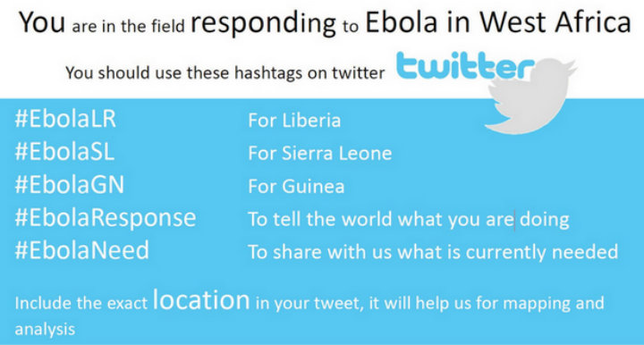
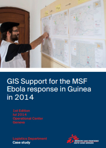
As technology for disaster response evolves, digital mapping is playing an increasingly important role in helping emergency managers in humanitarian emergency response operations. When considering the best tools and skills to respond to the Ebola crisis in West Africa, earlier this year, Doctors without Borders/Médecins Sans Frontières (MSF) sent a dedicated Geographic Information Systems (GIS) officer to Guinea, to support the local and international medical teams who are fighting the Ebola-outbreak. To find out whether that was a good investment, the MSF GIS Unit asked TC103 facilitator Timo Luege to write a case study showing the impact of this field-based GIS officer.

Some of the key observations are:

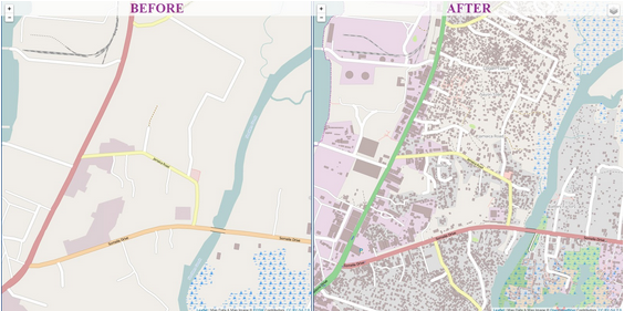
  • Most of the the areas close to the border of Guinea, Liberia and Sierra Leone had not been mapped previously. This meant that it was very easy to see the changes.

  • Despite being in a very remote area, the GIS officer had decent internet connection which allowed him to reach out for remote support. Among other things this made it possible for the volunteers of the OpenStreetMap community to contribute directly to supporting the response. So this is also a case that shows what crowdsourcing can contribute to humanitarian emergency response.

  • Since the GIS Officer was in the field, he and his local staff were able to provide context to the basemaps that were produced remotely. Both components were important: without the remote support, the GIS wouldn’t have been able to create all basemaps at the granularity that is available now. But without the GIS in the field, a lot of the traced outlines would not have been meaningful, because you need local knowledge to know whether a building is a school, a hospital, a police station etc. Also: assigning the correct names to villages is at least as important as mapping roads. Again, you need people in the field to do this.

  • Because MSF chose to use formats and tools that encourage or even require sharing, many maps created for MSF will add value to local communities, local government and help other humanitarian and development organizations working in the area. This means that the outputs will continue to be beneficial and can be built upon.

You can download the complete case study here:

GIS Support for the MSF Ebola response in Guinea in 2014

GIS Support for the MSF Ebola response in Guinea in 2014

This post originally appeared in Social Media for Good

Interested in learning more on how to use digital crisis mapping tools for humanitarian emergencies and natural disasters? Enroll now in this online course on Mapping for International Development and Tech Tools & Skills for Emergency Management.

About the TC 103 facilitator: Timo Luege

Timo Luege

After nearly ten years of working as a journalist (online, print and radio), Timo worked four years as a Senior Communications Officer for the International Federation of Red Cross and Red Crescent Societies (IFRC) in Geneva and Haiti. During this time he also launched the IFRC’s social media activities and wrote the IFRC social media staff guidelines. He then worked as Protection Delegate for International Committee of the Red Cross (ICRC) in Liberia before starting to work as a consultant. His clients include UN agencies and NGOs. Among other things, he wrote the UNICEF “Social Media in Emergency Guidelines” and contributed to UNOCHA’s “Humanitarianism in the Network Age”. Over the last year, Timo advised UNHCR- and IFRC-led Shelter Clusters in Myanmar, Mali and most recently the Philippines on Communication and Advocacy. He blogs at Social Media for Good and is the facilitator for the TechChange online course, “Tech Tools & Skills for Emergency Management“.

Image source: ReadyMarin

During an emergency, it is important to have ample information. Specifically, emergency management teams and affected populations need details surrounding the what, where, when, and how – as well as instructions for how – to respond, and communicate with coworkers and/or loved ones. While it is best to have a plan in place that includes how to receive this information with emergency kits and communication plans, it can be easy to forget to keep these plans up to date, practice them, or finalize them once started. On top of this challenge, the rapid lifestyle of professionals and the over-sharing of information through technology can lead to a very reactive and possibly dangerous outcome during a crisis.

The United States, like many societies, has become increasingly attached and sometimes dependent upon mobile technology and smartphones. Knowing this, how can we use this technology to stay better informed, to communicate better, establish better emergency planning, and stay calmer during times of crisis? Along with information on the importance of having and practicing emergency plans and building emergency kits, the Red Cross and the Federal Emergency Management Agency (FEMA) have used mobile technology by creating a number of mobile apps to help civilians administer First Aid, find shelter, and donate blood.

American Red Cross mobile app

American Red Cross natural disaster apps

The Red Cross labels most of their apps under “Natural Disaster,” to provide emergency information and alerts through reliable sources including the National Oceanic and Atmospheric Administration, and the United States Geological Survey, which provide instructions before/during/after the event, locate warnings based upon your area, and a number of other life saving and calming features. The Red Cross has separate apps for each disaster:

  • Tornado
  • Wildfire
  • Earthquake
  • Hurricane
  • Flood
  • Shelter Finder

The purpose of these separate apps is most likely to ensure users are getting the most up-to-date information as well as maintain accurate warnings and communication. However, managing these distinct apps might be irritating for users that live in an area that usually experiences more than one of the listed disasters. After installation, users are able to set up alerts to have their phone directly notify them of any warnings in their area. Two of the most helpful apps allow users to find shelters in their area and an “I’m Safe” alert. Shelter Finder allows users to locate open shelters, and view capacity, all using data from the American Red Cross National Shelter System, which often assists FEMA. Shelter Finder also contains information on 60,000 potential disaster facilities, and is updated every 30 minutes. “I’m Safe” is a customizable alert that connects to social media, and notifies friends and family on location and status. The Red Cross also suggests using their Safe and Well website or call 1.800.RED.CROSS, where individuals can register their status and location, and search for loved ones.

One of the key components to the Red Cross Emergency Apps is the dependence on phones lines and connectivity, which are often down or slow during times of crisis. Therefore it is suggested that family members have other plans in place including designated shelter locations.

Screen Shot 2014-11-17 at 1.38.54 PM

American Red Cross everyday app

Alongside the emergency apps, the Red Cross has also developed a number of everyday apps:

  • Blood: The first of its kind, makes giving blood convenient and allows users to find local blood drives and book appointments through the app, in addition to sending out blood
  • shortage alert messages during emergencies.
  • First Aid: Provides pre-loading offline instructions to guide you through first aid scenes
  • anywhere, integration and ability to call 911 from the app, safety tips, and educational
  • games.
  • Pet First Aid
  • Team Red Cross Volunteer
  • Swim
FEMA mobile app

FEMA mobile app

If users are looking for a more centralized emergency app, then definitely download FEMA’s mobile app; providing disaster safety tips, emergency meeting locations, information on open shelters and FEMA Disaster Recovery Centers, and the ability to use GPS to report and photograph disasters that are displayed on a public map. For non-smartphone users, FEMA also has a text message feature where users can receive safety tips for disasters and search for open shelters by texting 4FEMA.

Both organizations make it easy to streamline warnings, access vital information, and other
important alerts during an emergency. Mobile tools and apps allow even the busiest and
underprepared to have information readily available to them, and is definitely something that is recommended for everyone to have on his or her phone.

All Red Cross apps are available for download through the Apple Store and Google Play, in both English and Spanish. For more information on the Red Cross Plan & Prepare apps and more emergency planning materials visit: http://www.redcross.org/prepare/mobile-apps

For more information on FEMA’s Mobile App, Text Message Alerts, and more visit:
https://www.fema.gov/mobile-app

Interested in learning more about technology tools for emergency management and disaster response? Register now for our Technology for Disaster Response online course which begins next week on June 22, 2015.

Alumni bio:

Megan Penn

Megan Penn is completing her second year in the MA Security Policy Studies program at the George Washington University, Elliott School of International Affairs in Washington, DC. There, she is concentrating on Transnational Security Issues and Cyber Security Policy, with focus on human security, organized criminal activity, human trafficking, international institutions, and cyber security and information operations. While in classes, Megan has interned at a private aviation company, and currently works for a business development firm and writes for Freedom Observatory. Before DC, Megan completed a Bilingual Honours BA in International Studies at York University – Glendon College, in Toronto, Ontario. You can connect with Megan on LinkedIn.

by Timo Luege, TC103: Technology for Disaster Response facilitator

Wouldn’t it be wonderful if all public social media messages in a disaster would come with a flag that identifies them as relevant? The Office for the Coordination of Humanitarian Affairs (OCHA) is trying to pave the way for that with the brand new Hashtags Standards for Emergencies.

UNOCHA Hashtag Standards for Emergencies

The document builds on experiences gained in the Philippines where a set of standard hashtags such as #RescuePH or #ReliefPH have become so commonly used, that the government recently endorsed these as “official” disaster response classifiers to help identify needs. OCHA is now trying to elevate this system to the global level in the hope that we will start to see more consistency across countries and disasters. If successful, this hashtag standards could help disaster responders and their supporting software systems identify needs more quickly and reduce the amount of time needed to find relevant messages in flood of updates.

OCHA proposes three different types of social media hashtags:

  1. Disaster title hashtags. This type of hashtag (e.g. #Sandy) would be used by anyone to generally comment on an emergency (e.g. Hurricane Sandy) and would not be actively monitored by response agencies.
  2. Public reporting hashtags. By suggesting a specific hashtag that citizens can report non-life-threatening emergency items they see (e.g. #311US for broken power lines or a damaged bridge in the USA), we would be making sensors of the entire population. The resulting data could be scanned, mined and filtered to the relevant responding agencies.
  3. Emergency response hashtags. By providing a standard hashtag to trigger emergency response, based on local standards (e.g. #911US for the USA), we would enable citizens to tag content that is absolutely critical.  It would also enable responders to set up dedicated social media monitoring tools and channel the resulting information into their already existing mechanism(s). Social media would become an official information source.

(source: verity think)

I think this is great initiative and governments should pick up the ball and use this document as guidance for their own national strategies. That national authorities make this their own is essential because it can only work if the affected population knows about these hashtags in advance of the disaster and if the hashtags have been localized.

The graphic the report uses to illustrate the idea for the Ebola response is a good case in point:

Standard Hashtag

The suggested hashtags seem pretty straightforward until you take into consideration that Guinea is French speaking, meaning that people there probably will use something like #EbolaBesoin instead of the English #EbolaNeed.

Of course that would still be a huge step forward, since it would increase consistency even in cases where an emergency spans multiple countries and languages. After all, a limited number of hashtags that are used in multiple languages is still much better than no system. But it also shows that this document is not so much a blueprint as a concept study. It is now up to governments and other national disaster response organizations to make it work.

Interested in learning how social media and other technologies can help with disaster response? Enroll now to lock in your early bird rate for our Technology for Disaster Response online course that begins June 22.

This post originally appeared in Social Media for Good

About the TC 103 facilitator: Timo Luege

Timo Luege

After nearly ten years of working as a journalist (online, print and radio), Timo worked four years as a Senior Communications Officer for the International Federation of Red Cross and Red Crescent Societies (IFRC) in Geneva and Haiti. During this time he also launched the IFRC’s social media activities and wrote the IFRC social media staff guidelines. He then worked as Protection Delegate for International Committee of the Red Cross (ICRC) in Liberia before starting to work as a consultant. His clients include UN agencies and NGOs. Among other things, he wrote the UNICEF “Social Media in Emergency Guidelines” and contributed to UNOCHA’s “Humanitarianism in the Network Age”. Over the last year, Timo advised UNHCR- and IFRC-led Shelter Clusters in Myanmar, Mali and most recently the Philippines on Communication and Advocacy. He blogs at Social Media for Good and is the facilitator for the TechChange online course, “Technology for Disaster Response.

Photo source: Amnesty International

In the latest session of TechChange’s “Tech for International Crisis Response and Good Governance” class, I learned about the Panic Button, the emergency Android app recently launched by Amnesty International. The app is a step in the right direction for emergency alert applications, and may prove to be useful in other types of emergency situations. It was initially designed for activists working abroad, and essentially turns a cell phone into an alarm. While the app is running, the user can send pre-programmed SMS and GPS coordinates to three trusted contacts by hitting the phone’s power button multiple times. This simple process can be executed while the phone is located in the activist’s hand or pocket, and with minimal effort. With beta testing in 17 countries, this open source app was developed through an iterative process by networks of developers and activists, with two critical factors in mind: security and speed.

Pros. The speed of sounding an alarm is a major benefit of Panic Button, triggered by the power button on a user-friendly interface. This trigger allows users to be discreet in sending out an S.O.S. before their phone may be taken away by an adversary. Also, the GPS functionality provides trusted contacts with detailed information of where the person (or at least the phone) is located. This notification assumes that the activist has prepared ahead of time to both discuss with their contacts what to do in the event that an S.O.S. is received, and that they have turned the app on.

Cons. Security – particularly the interception of texts – remains a major concern. The app may reveal information about one’s location and contacts that could put all parties at increased risk. One of the major benefits of the app is sharing GPS coordinates, which need to be manually enabled. In an insecure environment, these may typically be switched off. The app needs to be switched on to work, which also means that the user needs to anticipate that they may be in a dangerous scenario – something very hard to do. These stipulations, as well as its learning curve, are potential stumbling blocks that need to be addressed.

Implications for sexual violence prevention. Despite these kinks, the Panic Button is a powerful tool. In its current state, Panic Button is specifically designed for activists, but its technology has the potential for use in other emergency situations, notably for women and girls at risk for sexual violence. Panic Button is similar to the award-winning and widely-used Circle of 6 app, but appears to be easier to use in an emergency situation. The ability to trigger Panic Button’s alarm without having to open the app itself is a critical differentiator and timesaver when an abduction or act of sexual aggression is occurring (similar to a scenario a Panic Button user would face). Circle of 6 is already being used in India, where not only sexual violence occurs on a far-too-frequent basis, but also where users are already comfortable using smart phones, and thus could also easily use Panic Button.

Panic Button is useful in environments that are dangerous and highly variable. With the open source nature of the app, one can only hope that the app will be adapted further to better address more specific challenges presented by additional contexts, and save both activists’ and women’s lives worldwide.

About Jessica Soklow

Jessica Soklow

Jessica Soklow is working toward her Masters in International Affairs at George Washington University’s Elliott School and is alumna of TechChange’s “Tech for International Crisis Response and Good Governance” course. Her concentration at the Elliott School is on international development, with an emphasis on developing and implementing programming with a gender-specific lens. Jessica has conducted extensive research on gender-based violence in international contexts, with a specific focus on prevention mechanisms in both India and the United States. She is optimistic about how technology can be used in the future to help prevent violence on a global scale.

Learn about tools like Panic Button and other technology in our upcoming online course on Tech Tools & Skills for Emergency Management, which has an early bird discount that ends Oct 31!

By Timo Luege, TC103: Tech Tools and Skills for Emergency Management facilitator

As Ebola continues to ravage Sierra Leone, Guinea and Liberia, people from all around the world are working together to stop the disease. In addition to the life saving work of medical staff, logisticians and community organizers, information and communication technology (ICT) is also playing a vital part in supporting their work.

After consulting the TechChange Alumni community and other experts in international development and humanitarian assistance, I pulled together a list of different technologies being applied to manage Ebola. Below are six examples showing how ICT is already making a difference in the current crisis.

1. Tracing outbreaks with mapping and geolocation
Aside from isolating patients in a safe environment, one of the biggest challenges in the Ebola response is tracing all contacts that an infected person has been in touch with. While that is difficult enough in developed countries, imagine how much more difficult it is in countries where you don’t know the names of many of the villages. It’s not very helpful if someone tells you “I come from Bendou” if you don’t know how many villages with that name exist nor where they are. The Humanitarian OpenStreetMap Team has helped this process through creating maps since the beginning of the response.

See: West Africa Ebola Outbreak – Six months of sustained efforts by the OpenStreetMap community.

Monrovia OSM pre-Ebola
Map of Monrovia in OpenStreetMap before and after volunteers mapped the city in response to the Ebola crisis. (Humanitarian OpenStreetMap)

In addition, the Standby Task Force is supporting the response by helping to collect, clean and verify data about health facilities in the affected countries. The information will then be published on UN OCHA’s new platform for sharing of humanitarian data.

2. Gathering Ebola information with digital data collection forms
Contact tracing involves interviewing a lot of people and in most cases that means writing information down on paper which then has to be entered into a computer. That process is both slow and prone to errors. According to this Forbes article, US based Magpi, who just won a Kopernik award, is helping organizations working in the Ebola response to replace their paper forms with digital forms that enumerators can fill out using their phones.

Digital forms not only save time and prevent errors when transcribing information, well designed digital forms also contain simple error checking routines such as “you can’t be older than 100 years”.

If you are interested in digital forms, check out the free and open source Kobo Toolbox.

3. Connecting the sick with their relatives using local Wi-Fi networks
Elaine Burroughs, a Save the Children staff member who is also TechChange alumna of Mobiles for International Development, shared that they are using their local Wi-Fi network to connect patients in the isolation ward with the relatives through video calls. Both computers have to be within the same network because local internet connections are too slow. In situations where video calls are not possible, they provide patients with cheap mobile phones so that they can talk with their relatives that way. Elaine added: “Several survivors have told us that what kept them going was being able to speak with their family and not feel so isolated when surrounded by people in hazmat suits.”

4. Sharing and receiving Ebola information via SMS text messages
I have heard about a number of different SMS systems that are currently being set up. Some are mainly to share information, others also to receive information.

mHero is an SMS system specifically designed to share information with health workers. It works with UNICEF’s RapidPro system, a white label version of Kigali-based TextIt which is one of the best SMS communication systems I know. RapidPro is also at the heart of a two-way communication system that is currently being set up by UNICEF, Plan International, and the Scouts.

The IFRC is of course using TERA to share SMS, a system that was developed in Haiti after the 2010 earthquake and already used in Sierra Leone during a recent cholera outbreak.

5. Mythbusting for diaspora communities via social media
Social media also has a place, though not as much as some people think. With internet penetration at less than 5 per cent in Liberia and less than 2 per cent in Sierra Leone and Guinea, it is simply not relevant for most people – unlike radio for example. However, all of these countries have huge diasporas. The Liberian diaspora in the US alone is thought to be as many as 450,000 people strong – and they all have access to social media. Experiences from Haiti and the Philippines show that the diaspora is an important information channel for the people living in affected countries. Very often they assume that their relatives in the US or Europe will know more, not least because many don’t trust their own governments to tell the truth.
Social media can play an important role in correcting misinformation and indeed, both the WHO and the CDC are using their social media channels in this way.

6. Supporting translations of Ebola information remotely online
Last but not least, Translators Without Borders is helping NGOs remotely from all over the world to translate posters into local languages.

Low tech does it
As a final word, I’d like to add that while technology can make a real difference we must not forget that very often low tech solutions will be more efficient than high tech solutions – it depends on what is more appropriate for the context. So don’t start an SMS campaign or launch a drone just because you can. It’s not about what you want to do. It’s not about technology. It’s about what’s best for the people we are there to help.

A Summary Infographic

TechChange Ebola Infographic

We will be discussing these technology tools, Ebola, and many similar issues in TC103: Tech Tools and Skills for Emergency Management and TC103: mHealth – Mobiles for Public Health. Register by October 31 and save $50 off each of these courses.

Do you have additional examples of how ICT is helping in the Ebola response? Please share them in the comments!

This post originally appeared in Social Media for Good.

About the TC103 facilitator: Timo Luege

Timo Luege

After nearly ten years of working as a journalist (online, print and radio), Timo worked four years as a Senior Communications Officer for the International Federation of Red Cross and Red Crescent Societies (IFRC) in Geneva and Haiti. During this time he also launched the IFRC’s social media activities and wrote the IFRC social media staff guidelines. He then worked as Protection Delegate for International Committee of the Red Cross (ICRC) in Liberia before starting to work as a consultant. His clients include UN agencies and NGOs. Among other things, he wrote the UNICEF “Social Media in Emergency Guidelines” and contributed to UNOCHA’s “Humanitarianism in the Network Age”. Over the last year, Timo advised UNHCR- and IFRC-led Shelter Clusters in Myanmar, Mali and most recently the Philippines on Communication and Advocacy. He blogs at Social Media for Good and is the facilitator for the TechChange online course, “Tech Tools & Skills for Emergency Management“.

“By Failing To Prepare, You Are Preparing To Fail.” – Benjamin Franklin.

In the last several weeks, I’ve been learning a lot about emergency response from TC103 facilitator, Timo Luege, who will launch the latest round of the Tech Tools & Skills for Emergency Management online course starting today.

Since I met Timo, I’ve been struck by his calm demeanor and composure, which is a key and necessary trait to sustain a career in emergency management and humanitarian aid in the face of crisis situations. After he shared some good practices for disaster emergency response, I asked him:

“How does one remain so calm when working in a career in disaster response?”

His answer?

Training.

According to Timo, “Training, preparation and having protocols and processes in place for different scenarios are the best guarantee for remaining calm during a crisis. This is especially true for security. There are too many organisations that don’t prepare or support their staff properly and expose them to situations they don’t know how to handle.”

That said, is there enough training in place for emergency managers to have more success in disaster response and resilience for future unforeseen disasters? What have been some of the best emergency management trainings and preparation guides?

What role can technology play in helping to manage disaster response? Looking to learn disaster response tips from professionals who have worked in disaster areas? Sign up now for this 4-week online course on Tech Tools and Skills for Emergency Management, which begins on November 24!


By Timo Luege, TC103: Tech Tools and Skills for Emergency Management facilitator

Working in humanitarian aid and disaster relief across several countries, I first joined the TechChange community as a student in the Tech Tools and Skills for Emergency Management online course in January 2012, and will soon be guiding discussions as a facilitator for the next round of the course that begins March 17, 2014. Since TechChange has offered this emergency management course six times since 2011, I’ve enjoyed stepping up my participation from student, to guest speaker, tech simulation demonstrator, to now a facilitator.

In my opinion, disaster management is a field where nobody is really an expert in that different people have varied areas of expertise. A facilitated TechChange course like TC103 is an opportunity to get people of different backgrounds together, which is especially valuable in a field like disaster management, which evolves so quickly and can be tough to keep track of.

Here are five lessons I have learned over the course of seven years of working in disaster response across Haiti, Liberia, Myanmar, Mali, and most recently the Philippines:

During radio programmes like this in the Philippines, disaster responders explained what assistance the survivors could expect in the aftermath of Typhoon Haiyan. Listeners submitted questions by SMS and via Facebook. Photo credit: Timo Luege

During radio programmes like this in the Philippines, disaster responders explained what assistance the survivors could expect in the aftermath of Typhoon Haiyan. Listeners submitted questions by SMS and via Facebook. Photo credit: Timo Luege

1. Build relationships early

Emergencies are not the right time for experiments. In the first phase of an emergency, disaster responders easily work 16 hours per day, seven days a week. This is not the right time to introduce new tools, unless they are an immediate time saver. If you are a technology firm, try to build relations with organizations before the next big disaster. Three months after the onset of a disaster can also be a good time to make contact, because at that stage, people have a little time to breathe but the needs are still huge.

Typhoon Haiyan was deadly in two ways: what the wind couldn’t destroy, the storm surge would flatten. Along the coast houses many houses were completely pulverized and cars thrown around like toys. Photo credit: Timo Luege

Typhoon Haiyan was deadly in two ways: what the wind couldn’t destroy, the storm surge would flatten. Along the coast houses many houses were completely pulverized and cars thrown around like toys. Photo credit: Timo Luege

2. Buy smartphones for your staff

Smartphones are amazing mobile tools that can do everything from taking photos to replacing paper forms to saving GPS information; however, many organizations still shy away from putting them into the hands of their staff. A basic, but functional, unlocked Android smartphone costs less than $80 USD in some of the more disaster prone parts of the world, and will save you many times that amount of money in gained productivity. Just think of all the paperforms you don’t have to manually enter.

Survivors tried to salvage as many building materials as possible, including wood, corrugated iron sheeting and even nails so that they could repair their homes as quickly as possible. Photo credit: Timo Luege

Survivors tried to salvage as many building materials as possible, including wood, corrugated iron sheeting and even nails so that they could repair their homes as quickly as possible. Photo credit: Timo Luege

3. Use tools that the affected population is familiar with

Information is critical for disaster affected people and they are eager to hear what is going on – even if it is bad news. Don’t try to impose your technology of choice on the affected people – find out what works for them. In one country it might be SMS, in another Facebook and in a third it will be old fashioned radio broadcasts or a combination of the above. As an organization, when designing your programmes, don’t focus on the tools but on what you want to achieve.

Even concrete houses like this could not withstand the force of the storm surge and were completely annihilated. Typhoon Haiyan damaged or destroyed close to 1.1 million homes. Photo credit: Timo Luege

Even concrete houses like this could not withstand the force of the storm surge and were completely annihilated. Typhoon Haiyan damaged or destroyed close to 1.1 million homes. Photo credit: Timo Luege

4. Make sure the tools you use work offline

Even in a country like the Philippines, where the infrastructure is comparatively good, access to the web will be spotty, particularly after a big disaster like the recent Typhoon Haiyan. Apps and browser-based tools that require you to save information online will only frustrate you. Make sure that whatever tool you are planning to use allows you to save information offline and synchronize later.

In Tacloban, a number of large ships were washed ashore by the typhoon. The survivors used the generators on some of these boats to supply them with electricity. Photo credit: Timo Luege

In Tacloban, a number of large ships were washed ashore by the typhoon. The survivors used the generators on some of these boats to supply them with electricity. Photo credit: Timo Luege

5. Learn Excel

While many new technologies are more sexy and exciting, Excel is the universal language of data during an emergency. Everybody is using it. The more you know about Excel and the better you are able to import data coming from Excel files, the more information you will be able to access, process and analyze and the better your understanding of the situation will be.

Have you worked in emergency management? What are tech tools that you found useful during that disaster?

Interested in learning more? Enroll now in the Tech Tools & Skills for Emergency Management online course, which runs November 24 – December 19, 2014.

About the TC103 facilitator: Timo Luege

Timo Luege

After nearly ten years of working as a journalist (online, print and radio), Timo worked four years as a Senior Communications Officer for the International Federation of Red Cross and Red Crescent Societies (IFRC) in Geneva and Haiti. During this time he also launched the IFRC’s social media activities and wrote the IFRC social media staff guidelines. He then worked as Protection Delegate for International Committee of the Red Cross (ICRC) in Liberia before starting to work as a consultant. His clients include UN agencies and NGOs. Among other things, he wrote the UNICEF “Social Media in Emergency Guidelines” and contributed to UNOCHA’s “Humanitarianism in the Network Age”. Over the last year, Timo advised UNHCR- and IFRC-led Shelter Clusters in Myanmar, Mali and most recently the Philippines on Communication and Advocacy. He blogs at Social Media for Good.

If you’re interested in learning more about this class, please check out the course page for more details on speakers and course topics or apply now to reserve your seat.

Time and accuracy are absolutely critical components of successful emergency management. While new technologies open the door for improved analysis and communication, they also introduce new challenges for managers coordinating response from disparate organizations both officially sanctioned and ad-hoc. Increased access and use of social media and mobile devices have resulted in an overwhelming deluge of data that must be processed and converted into actionable intelligence for responders. This coming Monday, January 21, we will begin our latest class in Tech Tools and Skills for Emergency Management to provide a survey of everything a technologist or emergency manager needs to know about integrating technology in an emergency.

One of the core differences between this course and some in the past is that we will be examining Hurricane Sandy as case study and example in self-organization and mobilization of volunteer networks using applicable technology. Representatives from two separate organizations involved in relief efforts will provide further insight into their experience bringing new tools to bear in this response:

Team Rubicon is an organization of veterans committed to disaster response. We’ve written previously about how they are adapting technology by Palantir from tracking IEDs to mapping disaster-affected areas.

We’ll also be joined by representatives from Occupy Sandy an affiliation of individuals who stepped up to provide relief materials to some of the hardest hit communities affected by the storm.

Here are just a few thing that we’re really looking forward to in this upcoming course:

  • Tech tools including: ArcGIS, FrontLineSMS, Ushahidi and OpenStreetMap
  • Case studies: Hurricane Sandy, the 2012 Philippines flood
  • Live events with experts such as: Keera Pullman of Esri, Andrew Stevens of Team Rubicon, and Kei Gowda and Robert Pluma of Occupy Sandy
  • A full simulation of a disaster in Samoa.

[UPDATE: Course rescheduled for April 8th, 2013]

We’re very sorry to inform you that we are rescheduling the Digital Organizing and Open Government course that was originally scheduled to begin on this Monday, January 7. If you have already paid for a seat in the course, we will (of course) refund your tuition in full if you so desire, or we will hold your spot in the rescheduled course as well as offering you a complimentary seat in our upcoming course: Tech Tools and Skills for Emergency ManagementThe reason for this unexpected schedule change at such a late date is that the Lead Facilitator, Christopher Neu, dislocated his shoulder and will be unable to type for several weeks. Rather than find a last-minute replacement, we opted instead to offer the course at a later date with the original experience intact. We apologize for any inconvenience and still hope to see you in class!


[ORIGINAL POST]

We’re excited about starting class on January 7th! We’ve already received applications from Senegal, Italy, Egypt, Spain, Cameroon, Kenya, Sweden, Haiti, India, UK, and more. However, we’ve had a number of questions about the course format, content, experts, and exercises that we wanted to address in more detail. Please let us know if this helps!

HOW IS THE COURSE ORGANIZED?

We’ve designed our courses specifically to combine self-paced multimedia content with real-time video engagement with experts. We have also included hands-on exercises to get you familiar with the tools under discussion under guidance from our staff. Courses are expected to take 5-9 hours per week of effort with a minimum of one real-time interaction, but can also be completed up to three months after the end of live courses. Broadly speaking, these are the themes that will be discussed during the four weeks of the course:

  • Week 1: Introduction to Core Themes (Jan. 7)
  • Week 2: Tech Tools for Digital Organizing (Jan. 14)
  • Week 3: Tech Tools for Open Gov and Open Data (US) (Jan. 21)
  • Week 4: Final Project–Toward Global Open Government (Jan. 28)

WHAT KIND OF CONTENT CAN I EXPECT?

Part of the course revolves around reading the latest research and discussing as a class. To that effect, we’ll be exploring the latest research from leading experts on “liberation technologies” such as Patrick Meier; crowd-sourced manuals (including one of our favorite: The Outsider’s Guide to Supporting Nonviolent Resistance to Dictatorship); and other videos, blog posts, and academic research. We try to balance the readings to contribute to expert discussions so that participants can dive deeper into core content in their field.

WHO ARE THE EXPERTS?

We’re excited about the broad panel of experts that we’ve lined up to hold live class discussions via video over the four weeks.

  • Kaushal Jhalla of the World Bank will be speaking about the challenges and potential of big data and development
  • Jordan Menzel of CrowdHall on the topic of using technology for public engagement and accountable government
  • Linda Raftree of Plan International, USA on open data and community engagement
  • Wayne Burke of the Open Forum Foundation on building sustainable communities around open government.

HOW DO THE HANDS-ON EXERCISES WORK?

Moving beyond content and experts, we’ve designed hands-on exercises for each week of the course to familiarize students with the tools under discussion.

  • Week 1: Explore application of social media tools with guides from Movements.org including Twitter and other social media.
  • Week 2: Public access tools such as CrowdHall to be used for engaging public figures in dialogue.
  • Week 3: Domestic/US-oriented open gov resources from Sunlight Labs including Open State Project, Stream Congress, and ClearSpending.
  • Week 4: International final project exploring open government in your home country: How can you get involved?


We hope this helps! Please let us know if you have any other questions by leaving a comment, tweeting @techchange, or sending an email to chris [at] techchange.org. Thanks!

“Team Rubicon is doing for disaster response what the Obama team did for political campaigns,” said Jonathan Morgenstein while taking a break from tearing down moldy drywall in hurricane-damaged Rockaway, Brooklyn. A New York native and US Marine Corps veteran who served two tours in Iraq, Morgenstein had spent the last month working on the campaign trail with Veterans and Military Families for Obama. He was referring not to the nearly fifty volunteers he was coordinating that afternoon, but rather the sophisticated software back-end that he was relying on to provide the correct information attached to the clipboard he was carrying. In the same way that better technology such as “Narwhal” had been credited with assisting him only weeks earlier for turning out more volunteers, donors and voters than in 2008 for Obama (“When The Nerds Go Marching In,” The Atlantic, 11/16/12), it was now playing a core role in coordinating disaster response in New York.

Jon Morgenstein in Rockaway, Brooklyn

Jon Morgenstein in Rockaway, Brooklyn

And on November 18, Morgenstein needed the help. In collaboration with Team Rubicon, he was responsible for supervising 48 Clinton Foundation volunteers to gut ten hurricane-damaged homes in preparation for their restoration by contractors. Morgenstein was one of hundreds of volunteers helping out with Team Rubicon during the Clinton Global Initiative’s “Day of Action for New York,” which pushed Team Rubicon organizing capacity to the limit. While it’s difficult to estimate exactly how much value has been returned to the community, gutting just one of the houses was estimated at $5,000-$8,000 for a homeowner without insurance (in this case a 91-year-old), making a direct value-add beyond food and shelter relief. And each house was tied to a work order and a map on Morgenstein’s clip board, just like while canvassing before the election.

But this particular software by Palantir Technologies wasn’t designed for campaigns, rather having been used recently for finding IEDs in war zones like Iraq and Afghanistan. According to a post on CNN (10/4/12), Palantir “software ties together intelligence data to improve information for troops about the possible location of roadside bombs planted by insurgents.” Nonetheless, it was also a perfect fit for an organization like Team Rubicon, which “unites the skills and experiences of military veterans with medical professionals to rapidly deploy emergency response teams into crisis situations.”  While the outpouring of people wanting to help has been heartening, new problems arise when organizing large groups of ad-hoc volunteers.

Volunteers from the Clinton Foundation  (Credit: Jon Morgenstein)

Volunteers from the Clinton Foundation

Fortunately, the tech fit the mission. Far from having an existing organizational structure or a known set of capabilities (like a proper military unit), this had been a seat-of-the-pants improvised human logistics, making those most in need with those most capable.  Palantir’s philanthropic team had been discussing doing some disaster-relief simulations to test its capabilities for this use.  When Sandy suddenly threatened the eastern seaboard, the drill became the real thing, with Palantir scrambling to set up the server infrastructure and mobile handsets for Team Rubicon’s use. (“Philanthropy Engineers Embed with Team Rubicon for Hurricane Sandy Relief,” Palantir Blog, 11/14/12)

The setup was ready by November 4th, just as recovery operations were swinging into gear. Imagined as operating system for data problems, Palantir’s software was able to pull in information from multiple sources of data, fuse it together into a coherent picture of the state of the peninsula, and then allow Team Rubicon operators to efficiently dispatch volunteers (say, a chainsaw team) to where they were needed the most (a list of the fifteen biggest downed trees). But tech isn’t perfect. “Check the data. At the end of the day, just because it’s in Palantir doesn’t make it right.” stated Brian Fishman of Palantir from inside the bus HQ. “Circumstances change, and a functional technology infrastructure requires regular updates to the data in the system.”

So, will Palantir and Team Rubicon change the way organizations think about disaster response? “I don’t know, maybe,” stated Morgenstein, “In the military we say, ‘Amateurs talk strategy, pros talk logistics’. These tech guys have made the logistics a lot easier at the operational level, and the military culture you see in Team Rubicon of delegating decision-making downwards to the person closest to the problem, is perfectly suited to an operation like this.”

Brian Fishman of Palantir at Team Rubicon FOB Hope

What we do know, however, is that putting the right tools in the right hands has the potential to create a team where the whole is greater than the sum of the parts. With Palantir and Team Rubicon, response operations will continue to iterate and improve over time, with the ultimate goal being to develop better response mechanisms for the next time disaster strikes. The best indicator of Team Rubicon as a learning organization may have nothing to do with the technology. At the end of the “Day of Action,” our team leader Zach (pictured, below right) turned to the group and asked us: “What could we do differently? If you see something you think we could be doing better, please let us know so that we can keep getting better at this.” Even when it comes to disaster response, tech is only ten percent.

TechChange provides online training in Tech Tools for Emergency Management. If you’re interested in learning more, consider applying for our next course. Class starts Jan. 14!

Interested in joining Team Rubicon? Please consider donating time or money to further their work. Learn more about Team Rubicon.

Zach and Dan of Team Rubicon

Zach and Dan of Team Rubicon