In recent years, mobile phones have drawn tremendous interest from the conflict management community. Given the successful, high profile uses of mobile phone-based violence prevention in Kenya in voting during 2010 and 2013, what can the global peacebuilding community learn from Kenya’s application of mobile technology to promote peace in other conflict areas around the world? What are the social and political factors that explain why mobile phones can have a positive effect on conflict prevention efforts in general?

1. A population must prefer non-violence since technology magnifies human intent

Context and intent is critical. One of the most important aspects of using mobile phones for conflict management and peacebuilding is recognizing prevailing local political climate. If a population is inclined toward peace in the midst of a tense situation, then mobile phone-based information sharing can help people promote peace and share information about potential hotspots with neighbors and peacebuilding organizations. Of course if the population has drawn lines and it ready to fight, mobile phones and make it far easier to organize violence. As Kentaro Toyama said, technology amplifies human intent and capacity. When integrating technology into conflict management and peacebuilding, the first step is to have a good idea of the population’s intentions before turning up the volume.

Photo: UN Women

Photo: UN Women

2. The events of violence start and stop relative to specific events

In the case of Kenya, violence erupted during particular period in the political calendar, namely during elections. Thus, violence starts and stops relative to external events, as opposed to being a state of sustained warfare. We have to be realistic about what we intend to do with the technology as it relates to peacebuilding or conflict management. In Kenya, prevention is made easier by the fact that the violence occurs around elections; the peacebuilding community has time to reach out to leaders beforehand, set up programs, test software, and organize networks of trusted reporters. It’s a different kettle of fish when violence is unrelated to something like elections, which are predictable. This starts to get into conflict early warning, where there are methodological and data challenges – we’ll be covering these in TC109, since they present some of the most interesting and difficult issues for conflict prevention.

3. The population knows to use their phones to share information about potential violence

Photo: UNDP

So the population prefers peace, and we all know when violence is going to happen. Now we have to make sure everyone knows that there are people listening when text messages are sent in reporting violence, and where those messages should be sent. Training and public outreach are key to making sure there is participation in a text message-based conflict management or peacebuilding program. This has to go on even when there aren’t high risk events like elections looming. One of the best examples of this kind of training and network building is Sisi Ni Amani, a Kenya-based NGO that does SMS peacebuilding, civic participation and governance training, and conflict mitigation around land disputes. By developing capacity within communities between elections, Sisi Ni Amani helps communities be prepared to respond to, and be proactive in, peacebuilding.

4. Third party actors involved in collecting and validating the crowdsourced data.

Never underestimate the value of having a third party involved in validating and rebroadcasting the information that comes from crowdsourced SMS text messages. In situations where trust between communities may be shaky, having the United Nations or a large NGO monitoring and responding to citizen reports can lend institutional credibility to the information being shared by local citizens.

Endnote: These factors were taken as excerpts from a recently published article titled, “Inter-ethnic Cooperation Revisited: Why mobile phones can help prevent discrete event of violence, using the Kenyan case study.” To read the entire published piece in Stability: International Journal of Security & Development, including works cited, please click here.

Charles Martin-Shields is a doctoral candidate at George Mason University’s School for Conflict Analysis and Resolution. He is currently a Fulbright-Clinton Fellow in Samoa, advising their Ministry of Communications and Information Technology on disaster response and data collection. Learn more from his primary research and also from other technology-for-peacebuilding experts by enrolling today in our upcoming Technology for Conflict Management and Peacebuilding course. The course runs January 13 – February 7, 2014. Group discounts available. Please inquire at info [at] techchange [dot] org.

 

This past Thursday and Friday (May 8 & 9) I participated in the ICTs and Violence Prevention workshop hosted by the World Bank’s Social Development Office.  We had an excellent collection of experts from across academia, NGOs, and government who discussed the complexities of using technology for violence prevention.  One of the key takeaways from the event was the analytic challenge of identifying where violence was likely to happen and how to encourage rapid response.

The problem of preventing violence centers of two things; predicting where violence will occur and the ability for institutions to respond.  Emmanuel Letouze, Patrick Meier and Patrick Vinck lay this problem out in their chapter on big data in the recent IPI/UDNP/USAID publication on ICTs for violence prevention.  They point out that instead of using big data to aid interventions by large institutions, that big data can be analyzed and packaged so that local actors can use it to respond immediately when they see signs of tension.  I used this model in my talk on crowdsourcing; the goal is for the big organizations to leverage their processing and analytic capacity to produce data that can be used by local actors to respond to tension and threats of violence themselves.

What made the discussion around this challenge so interesting was that the speakers and audience were able to focus not just on the technology, but also on the ways that different cultures understand information and space.  Matthew Pritchard of McGill University gave a fantastic talk about the challenges of mapping land tenure claims in Liberia, since people expressed land ownership in different ways.  He explained that GIS mapping could contain the data on how people understand their relationship to the land – maps layers could have MP3 recordings of oral history, photos of past use, and graphical demonstrations of where borders were.  Finding ways to move beyond external perceptions of local conflict drivers was one of the goals of the discussions, and integrating technology and social science more effectively is increasingly going to be a way to achieve that goal.

This event was also bittersweet for me, since it was my last time officially representing TechChange as their Director of Conflict Management and Peacebuilding.  Starting May 9, I will be joining Mobile Accord as GeoPoll’s Research Coordinator.  After over two years working with Nick Martin and the team at TechChange, I’ve decided it’s time to focus more on data and analytics in the ICT for development space.  While I’m excited for this new challenge, I’ll miss working in the loft where I’ve learned almost everything I know about ICT4D and tech for conflict management.  I wouldn’t be where I am academically or professionally without the insights and support of the colleagues and friends I’ve made at TechChange.  While I’m looking forward to joining the team and GeoPoll, I’ll always be excited to check the blog or cruise by the office to see what amazing new animation or interactive learning platform Will Chester and the TechChange team have conjured up!

This is a guest post by Dhairya Dalal. If you are interested in using crisis mapping and using technology for humanitarian relief, conflict prevention, and election monitoring, consider taking our course Technology for Conflict Management and Peacebuilding.

Overview

Recently, I had the opportunity to run an election monitoring simulation for TechChange’s TC109: Conflict Management and Peacebuilding course. Led by Charles Martin-Shields, TC109 taught over 40 international participants how mapping, social media, and mobile telephones could effectively support the work of conflict prevention and management.  Robert Baker taught participants how the Uchaguzi team leveraged crowd-sourcing and Ushahidi, a web based crisis mapping platform, to monitor the 2013 Kenyan elections.

For the simulation activity, my goal was to create a dynamic hands-on activity. I wanted to demonstrate how crisis mapping technologies are being used to promote free and fair elections, reduce electoral violence, and empower citizens. To provide students a realistic context, we leveraged live social media data from the Kenyan elections. Participants walked through the process of collecting data, verifying it, and critically analyzing it to provide a set of actionable information that could have been used by local Kenyan stakeholders to investigate reports of poll fraud, violence, and voter intimidation.

Below I’ll provide a brief history of election monitoring in the context of Kenyan elections and provide a more detailed look at the simulation activity.

Brief History of Election Monitoring and Uchaguzi

uchaguziIn 1969, the Republic of Kenya became a one-party state whose electoral system was based on districts that aligned with tribal areas. This fragile partitioning often generated internal friction during the electoral cycle. The post-election violence of 2007-2008 was characterized by crimes of murder, rape, forcible transfer of the population and other inhumane acts. During the 30 days of violence more than 1,220 people were killed, 3,500 injured and 350,000 displaced, as well as hundreds of rapes and the destruction of over 100,000 properties. 2

Ushahidi was developed in the wake of the 2008 post-election violence. Ushahidi, is a website that was designed to map reports of violence in Kenya after the post-election fallout. However, Usahidi has since evolved into a platform used for crisis mapping, crowd-sourced data gathering, and many other things. Since then, the name Ushahidi has come to represent the people behind the Ushahidi platform. 2

Uchaguzi was an Ushahidi deployment, formed to monitor the 2013 Kenyan general elections held this past March. The Uchaguzi project aimed to contribute to stability efforts in Kenya, by increasing transparency and accountability through active civic participation in the electoral cycles. The project leveraged existing (traditional) activities around electoral observation, such as those carried out by the Elections Observer Group (ELOG) in Kenya.3

Election Monitoring with CrowdMaps

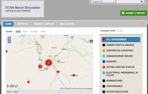
TC109 Simulation Figure 1: TC109 Simulation map (view official Uchaguzi map here: https://uchaguzi.co.ke/)

For the simulation activity, we used Ushahidi’s CrowdMap web application. CrowdMap is a cloud-based implementation of the Ushahidi platform that allows users to quickly generate a crisis map. Crowdmap has the ability to collect and aggregate data from various sources likes SMS text messages, Twitter, and online report submissions.

To provide the participants a more realistic context, our simulation collected real tweets from the Kenyan elections that had just occured the prior week. Our simulation aggregated tweets from Uchaguzi’s official hashtag, #Uchaguzi, as well several other hashtags like #KenyanElections and #KenyaDecides. In addition students were tasked with creating reports from Uchaguzi’s facebook page and local Kenyan news sites.

The aggregated information was then geo-tagged, classified and processed by the participants. The participants created reports, which described incidents licrowdmapke instances of voter intimidation, suspected poll fraud, and reports of violence. The CrowdMap platform plotted these reports on a map of Kenya based on coordinates the participants provided during the geo-tagging phase.  The resulting map showed aggregation patterns, which would have allowed local actors to see where certain types of incidents were taking place and respond accordingly.

Conclusion: Going beyond the Technology and Cultivating Information Ecosystems

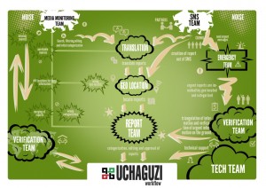
workflow   Figure 2: Uchaguzi Workflow

While technological innovations have made it easier to collect vast amounts of data in real-time during a crisis or an live event, a lot of process and human capital is still required to ensure that the data can processed and acted upon. Prior to the Kenyan elections, the Uchaguzi team established a well-planned information workflow and local relationships to ensure that information was ultimately delivered to the local police, elections monitors, and other stakeholders who could take action on the reports received. This workflow also delineated volunteer workgroups (based on Standby TaskForce’s information processing workflow) which were responsible for different parts of information collection process from Media Monitoring and Translation to Verification and Analysis.

To provide the participants an understanding of the full picture, we had them assume the role of various workgroups. They were challenged to identify how the information would be gathered, verified, classified, and distributed to local stakeholders. Participants followed the official Uchaguzi workflow and learned more about the challenges faced by the various workgroups. For example how would you translate a report submitted in Swahili? How would you determine if a report is true or falsely submitted to instigate provocation? How would you escalate reports of violence or imminent danger like a bomb threat?

Overall, the participants were able to learn about both the technology that enables the crowd-sourcing of election monitoring and the strategic and deliberate structures put in place to ensure an information feedback loop. Participants were able to gain an understanding of the complexity involved in monitoring an election using real data from the Kenyan elections. They were also given an opportunity to recommend creative suggestions and innovations that were sent to the Ushahidi team for future deployments.


About the Author:
Dhairya Dalal is a business systems analyst at Harvard University, where he is also pursuing his master’s degree in Software Engineering. Dhairya serves a curriculum consultant for TechChange and is responsible for teaching hands-on technical workshops centered around crisis mapping and open gov APIs, as well as strategic lessons on social media strategy and digital organizing.

Sources:
1:Background on the Kenyan Electoral Violence
http://www.haguejusticeportal.net/index.php?id=11604 
2: Uchaguzi Deployment
https://wiki.ushahidi.com/display/WIKI/Uchaguzi+-+Kenyan+Elections+2013
3: Uchaguzi Overview
http://reliefweb.int/report/kenya/uchaguzi-kenya-2013-launched

The past weekend was busy for the crisis mapping community, with a very full four days of events at the International Conference on Crisis Mapping.  While the ignite talks and self-organized sessions were fantastic what capped off the weekend for about 30 of us was the day-long activation simulation of the Digital Humanitarian Network (DHNetwork).  This effort was made possible by the support of the ICT4Peace Foundation who provided funding for logistics and for TechChange to design and carry out the simulation. UN-OCHA provided travel support to DHNetwork members who needed assistance in order to ensure that all entities could participate.  As well, key observers such as UN-SPIDER, USAID, the State Department, Department of Defense, Harvard Humanitarian Initiative (HHI), and the Woodrow Wilson Center were invited to be present and give direct feedback throughout the day.

(more…)

Image Source: Ushahidi

Mini Biography

Adam Papendieck has an MPH from Tulane University and a technical background in GIS, Statistics and Information Systems.  He is currently the Sr. Program Manager for Technology at the Payson Center for International Development at Tulane University, where his role is to leverage appropriate and innovative information technologies in support of research projects, funded Public Health capacity-building projects in East Africa, and crisis informatics activities with the Disaster Resilience Leadership Academy.  He has worked on applied ICT activities such as the creation of a dynamic web mapping application for the World Vision US corporate information portal, the design and implementation of open source thin client computer labs in Rwanda, the creation of e-learning platforms at African institutions of higher education, various crisis mapping initiatives and disaster analytics activities for the Gulf Oil Spill, Hurricane Katrina and other events. (more…)

After 40 years of rule, Colonel Gaddafi is gone.  Reports say he was killed today in a military offensive in Sirte, Libya after a protracted insurgency that was backed by NATO forces.  While there is room for a conversation about NATO’s actions, whether they’re an example of Responsibility to Protect doctrine, and normative questions of supporting violence.  In the immediate though, history tells us that the more effectively we can help Libya achieve a stable political and economic situation, the more likely we are to see a stable peace.  This is an area where emerging mobile technology and crisis mapping could prove valuable to the development and peacebuilding communities.


There is already an example of Ushahidi’s mapping platform being used to track the violence and gather data for the UN Office for the Coordination of Humanitarian Affairs (OCHA).  The launch of this map was managed by OCHA with volunteers from the Standby Volunteer Task Force.  As Patrick Meier explained at iRevolution, this deployment was called for by OCHA with a predefined set of data management processes and a fully trained team of mappers.  In this example we see the humanitarian community grasping the value of mapping technology and supporting the systems to make it viable in what was an evolving conflict situation when the map launched in March 2011.  You can see the public map here.


Having seen a proof of concept for crowdsourcing in the form of the Ushahidi map, Libya in the post-rebellion stage could be a case study for how mobile technology might be leveraged going forward to develop participatory government, rebuild an economy, and provide the citizenry with decentralized access to information.  The high level of mobile penetration means that crowdsourcing tools such as FrontlineSMS could be valuable for gathering and disseminating information about access to health care and justice, as well as supporting participation in governance functions at the local and national levels.


A large part of a successful transition will hinge on the desire of Libyans to develop a system of governance that is right for them with the support of the international community, and mobile telephony is only part of the equation.  SMS crowdsourcing and tools such as FrontlineSMS could provide a great deal of value in the transitional process as stability returns to Libya.  I’d like to invite everyone to comment and start a discussion about where we see technology fitting into Libya’s development going forward.


 Charles Martin-Shields is TechChange’s Director of Special Projects and Simulation Design.  He  is also a doctoral student at the School for Conflict Analysis and Resolution at George Mason  University, where his research focuses on conflict management, technology and analytic  methodology.  He can be reached at charles@techchange.org and you can follow him on Twitter  @cmartinshields.

In his recent article on MobileActive.org, Paul Currion posed the question, “If all You Have is a Hammer, How Useful is Humanitarian Crowdsourcing”. Currion argued that those working in disaster response “…don’t need more information, they need better information.” He argued that Ushahidi’s Haiti deployment was an example of the failure of crowdsourcing to add value to disaster response efforts and ongoing humanitarian work. This pointed critique of Ushahidi and the use of social media in a humanitarian context resulted in an enthusiastic, and sometimes heated, debate in the article’s comments section.

(more…)