Digital Data Collection with Remote Sensors and Satellite Imagery
|
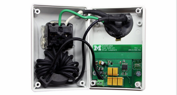
Monjolo energy-meter sensor created by University of Michigan’s Lab11. Image credit: Umich Lab11
How can remote sensors and satellite imagery make monitoring and evaluation easier and more accurate than pen-and-paper surveys?
In my most recent post on many of the technology tools for M&E we discussed in the inaugural round of TechChange’s Technology for M&E online course, the course participants and I shared several of the current digital data collection tools. These tools include Open Data Kit (ODK), Magpi, SurveyCTO, Taro Works, Mobenzi, Trackstick, and Tangerine.
Generally speaking, global development recognizes the benefits of mobile data collection–as Kerry Bruce said in the first course, mobile data collection is a “no brainer.” But what kind of cutting-edge technologies like remote sensors and satellite imagery are available for collecting large amounts of data more efficiently and accurately?
In this upcoming round of the course, we will be highlighting these cutting-edge technologies, how they have been used in development, and how they can change data collection methods. Satellite imaging is being used to remotely monitor illegal mining, urban development, and deforestation in real-time. Remote sensors provide accurate, real-time measurements for the adoption of water pumps or cookstoves by detecting motion and reading temperature.
We’re very excited to have presentations from the Center for Effective Global Action (CEGA) in the upcoming TC111: Technology for Monitoring and Evaluation course. CEGA is a global development research network that works to create actionable evidence for policy makers and program designers. They also design and test new technologies to find new solutions to the problem of poverty.
CEGA is researching how remote sensors and satellite imaging can help create more accurate measurements. We have three researchers on this topic joining us in the course: Guillaume Kroll from CEGA’s Behavioral Sensing program; Dan Hammer, a Presidential Innovation Fellow working with the White House and NASA to increase access to satellite imagery for the non-profit sector; and Pat Pannuto who researches sensors at Lab11 and is working on numerous projects with CEGA.
Dan Hammer was the Chief Data Scientist at World Resource Institute’s Data Lab and worked to analyze deforestation from satellite images. In a recent article, Guillaume highlights how remote sensors are reshaping the way we collect data and highlights CEGA’s success with stove usage monitors in Darfur. Pat presented at the Development Impact Lab’s State of the Science on how remote sensors can be used for data collection and monitoring (slides available here). Pat is trying to “solv[e] the ‘last inch’ problem: bringing connectivity and computing capability to everything” and thinking about how connected devices (the Internet of things) can impact global development.
Patrick Pannuto: “Sensing Technologies for Data Collection & Monitoring”
Interested in learning more about the cutting edge technology for M&E including remote sensors and satellite imagery? Join our upcoming course on Technology for Monitoring and Evaluation.
Frontline health workers in Guinea, Sierra Leone, and Liberia are responding to the largest Ebola outbreak in history. To protect...
Posted by Arjen Swank from Text to Change, guest speaker for TC105: Mobiles for International Development Since 2008, Text to...
Green infrastructure hasn’t always been a priority in urban development. Now, more than ever, green spaces are an essential component...